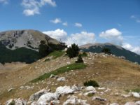
The Pollino National Park covers 192.565,00 hectares of land and is located between the regions of Basilicata (also called Lucania) and Calabria. On the west, it ranges from the Tyrrhenian Sea to the Ionian Sea, from Cozzo del Pellegrino to Serra Dolcedorme, from the Piani di Campolongo, Novacco, and Lanzo, to Piani del Pollino, from the rivers Argentino and Abatemarco, to the gorges of Lao and Raganello, to the Peschiera torrents and Frido. The whole area of Pollino is formed by the Massicci del Pollino and Orsomarso. The mountain range that is part of the southern Apennines bordering the Basilicata and Calabria boasts the highest peaks of southern Italy which remain snowy for a long period starting from November and ending in May with the melt the first snow. The height of its peaks reaches 2,200 meters above sea level. This natural area enjoys great prestige and is composed of dolomitic rocks, limestone bastions, walls of architectural fault, cliffs, very deep gorges, karst caves, volcanic timbers, sinkholes, plateaus, meadows, high altitude pastures, morainic accumulations, glacial cirques and erratic boulders.
Comments are closed.
By continuing to use the site, you consent to the use of cookies. more information
The cookie settings on this website are set to "allow cookies" to provide you with the best possible browsing experience. If you continue to use this website without changing your cookie settings, or if you click "Accept" below, you consent to this.